Subdivisions
A subdivision creates multiple parcels of land from an existing tract of land. Subdivision design is the art of seeing what the land has to offer, working within the applicable laws to design a development that will serve the future owners and the municipality.
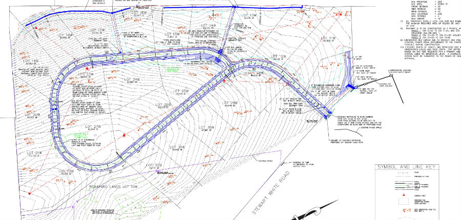
Subdivision Design and Permitting
Designing a subdivision is sometimes very straightforward. Simple projects need only take into consideration the local zoning requirements to meet things such as minimum frontage and minimum lot size for the zoning district in order to create a new parcel. Larger residential subdivisions, commercial subdivisions or land that has more environmentally sensitive areas or environmental resources are inherently more complex. Trinity’s design process moves the project from a conceptual design, to preliminary subdivision design, and on to a final subdivision design. The conceptual design stage builds information in the form of a basemap, it identifies challenges, generates options, and establishes budgets for field work and other studies that are necessary to validate the options. Throughout the process, the client is made aware of the various permitting thresholds that trigger the need for various permits. Contact us or review some of our other design services to get a better sense of the permitting thresholds that might apply to your project.
Trinity is able to utilize the latest survey and mapping technologies including LiDAR, RTK GPS and Geographic Information Systems (GIS) data sources to quickly generate a conceptual plan that contains such things as contours, mapped wetland areas, soil types and floodplains. Additional resources, from on line land records research and aerial mapping can provide other features to quickly bring the project into focus, in order to identify options and to develop permitting timelines. A conceptual plan can either ‘test’ the vision presented by the client or it can be used to generate options for the client.
Through the Preliminary Design, we to continue to narrow the options and attempt to identify potential ‘show stopper’ issues, long lead design items, or sequential design items in order to arrive at a more refined schedule. We look to create permitting ‘pathway’ early in the process. By implementing field work and engaging the regulators we move the project to the next level. The permitting pathway is continuously updated, validate, and adjusted as needed, all with client input a key junctions in the project.
Subdivisions in Massachusetts
In Massachusetts, subdivisions are reviewed by the Planning Commission of the municipality under the Subdivision Control Act. Provided that a proposed lot has frontage in one of the three types of ways specified in Chapter 41, Section 81L, MGL, and the lots shown on such plan meet the minimum frontage requirements, and the Planning Board has determination that the vital access to the lots exists, then the proposed subdivision can proceed as a Form A subdivision. A Form A subdivision is also known as an Approval Not Required, or ANR lot. The proposed lots must also comply with the applicable zoning requirements, as well as, any other state or local laws or ordinances. Subdivisions that require a new road or right of way to create the frontage required for each lot proceed as a Form C subdivision.
Subdivisions in Vermont
In Vermont, subdivisions require state and local approval. Local zoning applies as it relates to such things as minimum area and minimum frontage requirements. Subdivisions may also require review and approval by the local Development Review Board (DRB). A state subdivision permit is required for most subdivisions. Subdividing more than 6 lots (or 10 lots in certain towns) within a 5 year period can trigger the need for a state Act 250 permit.
Trinity can also perform a Feasibility Study for a prospective land owner seeking to invest in a parcel of land. A Feasibility Study is an valuable investment, which can help you to understand the options and limitations on a parcel of land. Similar to a conceptual plan, a Feasibility Study generates a base map of information to help better understand the potential investment.