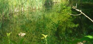
Wetland Resources Delineations
Wetland resource areas provide valuable functions that may not always evident. Wetlands play a significant role in recharging groundwater supplies, provide habitat function that promotes biodiversity, create healthy fisheries, provide storage and detention of floodwaters that can greatly mitigate damage from rainfall and provide removal of pollutants. A wetland delineation defines the ‘line’ that divides the wetland resource area from the upland area. Permitting is required for activities within a wetland resource area and within the buffer zone. The buffer zone is the upland border immediately adjacent to the edge of the wetland. The buffer zone width can vary based on the regulations that apply.
Wetland Delineations and Permitting
Wetland regulations derive their authority from the Clean Water Act (CWA) but can be administered by the state or at the federal level through the U.S. Army Corp of Engineers (USACE). Some municipalities have passed their own wetland by-laws. Wetlands delineations must be performed during the ‘growing season’ in order to properly speciate the vegetation.
Vermont has established three classes of wetlands, Class I, Class II and Class III. Class I wetlands are fairly rare and are considered exceptional and irreplaceable and have a 100′ buffer zone. Class II wetlands are more common, have a 50′ buffer zone and their approximate locations have been mapped by the Vermont Significant Wetland Inventory (VSWI). Class III wetlands are not mapped by the VSWI, and have no buffer zone. Class III wetlands are not regulate by the state of Vermont, but are regulated by the USACE. VSWI maps are helpful to determine the general location of Class II wetlands, but cannot be taken to be exact. Field verification and delineation is needed to accurately locate the wetland boundary if work is planned within or near the buffer zone. Additionally, what may appear to be an unmapped Class III wetland might actually be determined to be a Class II wetland if it is associated with a Class II wetland by a hydraulic connection. Significant project delays can occur if the wetland delineation is not performed and reviewed by the state within the growing season.
Massachusetts regulates wetlands, as well as, other resources areas through the Wetland Protection Act (WPA). The WPA (310 CMR 10.00) actually regulates only Bordering Vegetated Wetlands (BVW), not isolated wetlands. Isolated wetlands in Massachusetts are regulated by the USACE. The WPA also regulates Banks of streams, Land Under Water Bodies and Waterways, Isolated Land Subject to Flooding, Bordering Land Subject to Flooding and Riverfront Areas. Projects subject to the WPA that are also within rare species habitat (Estimated Habitat or Priority Habitat) will need to comply with the Massachusetts Endangered Species Act (MESA) and may require a wildlife study or botanical study to assess whether a listed species is in fact present. Projects subject to the WPA may also need to comply with the Massachusetts Stormwater Standard as well.